 Esri, Maxar, Earthstar Geographics
 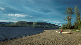 Photo: BC Parks
 Moberly Lake Provincial Park
BC Parks inside Moberly Lake Parkwhat to expect
Moberly Lake Park is situated on the southern shore of Moberly Lake which is found on the boundary between the Rocky Mountain foothills to the west and the Peace plateau to the east. The lake itself lies in a broad shallow valley of the Moberly River, about 96km from its junction with the Peace River. Enjoy a leisurely stroll along the lakeshore and pull up a bench to watch the sunset. Stop and visit the park’s interpretation kiosk to learn about the local flora, fauna and history. While you are there, take time to listen to the loons or look overhead for bald eagles. Head down to the lake for a swim or to test your luck fishing for northern pike, lake trout and lake whitefish.
Description: BC Parks
the basics
find more: campgrounds with playgrounds near here → ·campgrounds with pet-friendly sites near here →
the campsites
things to do here
Activities you can do at Moberly Lake Provincial Park.
things to do nearby
Within 5 km — trails, viewpoints, beaches, boat launches you can reach without packing up camp.
Plus 1 user-tagged boat launch on OpenStreetMap — visible as pins on the map below.
water + services
1 user-tagged dump station on OpenStreetMap.
what to know
Updated each morning from provincial parks and Environment Canada.
other campgrounds nearby
Other places to stay within 25 km.
- Moberly Lake Marina Ltd
- Sagitawa Christian Camping
- Westwind RV Park
- Aspen Place
- Cameron Lake Campground
- Caron Creek RV Park
Plus 2 user-tagged dispersed sites on OpenStreetMap — often genuine wild-pitches; check access rights before relying on one.
keep an eye on Moberly Lake Provincial Park
Every Thursday we send the weekend list: which campgrounds still have sites for the coming weekend, plus fire bans and new conditions. We’ll tag you to this park so its alerts reach you first as they roll out.
One email. Unsubscribe anytime. We don’t share addresses. — chris@calgaryanalytica.ca